walk the earth

Saturday, October 15, 2005

Eye Candy. well, almost...

Here's some more photos from the trek:


The route from Dzongla towards the Cho La pass. The pass is up the mountains straight ahead of Tim in this photo. Looks like the obvious route, yeah?


Here's a shot of a few of us crossing the glacial moraine with that wonderful black dog, not the best weather...

Sorry, the internet is suuuper slow at the moment, photos won't upload. Will try later...

Over the Cho La Pass...

Here's a excerpt from my written journal about one of the more exciting days we had on our trek...

10/9/2005 Dzongla- Cho La - Gokyo

We woke up in Dzongla, had breaky, waited for the clouds to pass. We walked for only a brief bit in cloud until the powerful sun burned of the layer, exposing the beautiful valley below and the dizzying pass above. We continued up a flatish section and observed some trekkers making their way up the very steep and rocky pass. As we approached the pass, I got pretty tired up the twisty switchbacks just before the rock scramble, but we were all feeling the elevation, and took a break before heading up. At the base of the pass we met up with an Indian guy who was resting, and having a cigarette... He gave us some dried fruit and we were happy to rest there a while.

Matt led up the first pitch of the scramble, very shaky with our full packs on, but manageable. It was hands, knees, and feet up the first couple hundred feet. We all did fine and made it to the top without drama, I had used "sherpa socks" (put my feet and socks in plastic bags, then in my shoes, to prevent snow/water getting in. Using only trail runners has been great and light thus far, but could have used some proper boots at this point.)

We rested at the top of the first steep section, took some photos and drank water. The next section was a glacier crossing, which was just like on Rainier after Camp Muir, pretty flat, but hoping over a few crevasses via snowbridges and playing in the snow. Sherpa socks did their trick. We started to see more and more trekkers on this section, which was a welcome site, as we could get good route info from them as they had just come up the other side. The down side of the pass was completely snow covered from the storm the night before, and was in bad shape. We rested at the top of it with a few other folks, then headed down. I led and it was very slick, totally snow covered and steep. I twisted my left knee on one of the rocks, and had to nurse it all the way down, but it was fine later. Route finding was hard on the bottom section because we couldn't see any footprints to follow, but we eventually found the right path and successfully made it to the bottom. Had a well deserved rest, the concentration and altitude was pretty tiring. The pass tops out around 17,400ft.

We rested in a makeshift campsite a few k's from the bottom of the pass, I was out of water, only had 2 liters with me, and had one of my rehydration packs, Tim was feeling it too, and had one as well. We still had a to cross an unknown number of valleys to get to Thangnak, the next closest village and our desired lunch stop. We made it over with ease, as we were now quite a bit lower, and could really breathe well. Just before Thangnak, we saw the Dutch brothers, Gerhardt and Yann, resting my a stream. They had stayed in the same tea house as us in Dzongla. I filled up a bottle, and iodined it to be safe, it was ready to drink in about 15 minutes and I was damn thirsty, it was so cold and refreshing. An easy walk into Thangnak, and in minutes I was enjoying a massive plate of veggie fried noodles and black tea. We eat and rested, Charlie the British traveler in his 50's, who we had met a few times before was there an joined us. Charlie's amazing, has been traveling constantly for the past 8 years, an ex-geologist for the big oil companies, he said "I was a grown man and was drawing lines on pieces of paper for a living. So I checked the bank account, and told my boss, 'Thanks, I'll see ya later.' I'm trying to travel for a decade, year and a half to go." He usually can be found in Zambia with his girlfriend, or in Indonesia, where the going's cheap.


FOLLOW THE BLACK DOG...
What happened next was astonishing. After Thangnak, we had to cross the Ngozumpa Glacier to get to Gokyo, our final destination for the day. Following the trail from Thangnak with the Dutch brother, not really paying attention, chatting about soccer, Holland, and sports, the trail abruptly ended at a massive glacial lake. At this point we were pretty much into the glaciers moraine, a very rocky and unsettled area. During lunch dark clouds had moved into the valley, it was now foggy and snowing lightly. We decided to back track towards Thangnak and hopefully find a trail around the lake that we must have missed. Blazing a new path looked quite un safe over steep loose rocky terrain. We never found an alternative path, so went all the way back to Thangnak. At Thang, things got interesting. At the first lodge we met a British guy who helped us out, he led us to where he thought the "new path" to Gokyo lead, apparently we had been on last years route, which had been wiped out by the lake. It was all made more difficult by the bad weather and poor vis. While this was going on, a little black dog was under foot, not all that uncommon. There's wild dogs all over Nepal.

The British guy lead us as far as the glacier's moraine, and pointed us in the direction he thought would get us through to the other side. There were tiny trails all over the place, and many intersections, it was a bit confusing and getting late at this point. We noticed the same black dog was ahead of us on the trail, and all sorta of decided we'd follow him, since he was the only one that seemed to know where to go... Well, we ended up following the dog for the next two hours through the whole glacier and directly to Gokyo! The glacier moraine is a landscape from another world, without the dog leading, we would have gotten lost a bunch of times...And wouldn't have made it to Gokyo before dark.

The Dutch guys and the three of us were walking in amazement, the fog, snow, terrain, dog all came together to make it a memorable walk. We fed the little dog some crackers and water when he would wait for us to catch up as we fell behind. Got some pictures of him and the terrain which I'll upload asap.

We got into Gokyo just before dark and found a lodge which was free to stay as long as we bought dinner there. Sweet, and Dave and Francois were there, two great guys we had met a few times before on the trek. Had a filling meal and talked about plans with the rest of the crew. Another day that I will never forget.

Wednesday, October 12, 2005

The bottom of the top of the world

This is what we came to see: Mt. Everest.


The Crew and Mt. Everest:


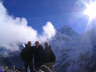
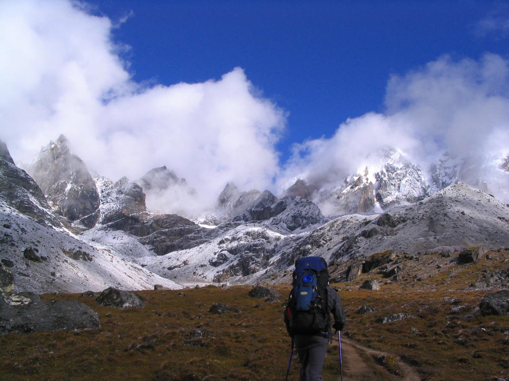
We're at about 18,000ft here, on Kala Pattar, over looking Mt. Everest (the tall one) also in the shot is Nuptse (far right) and the West Shoulder of Everest (forground). We got up at 5am to start the hike up Kala, it was still completely dark and fun with our headlamps lighting the way. We watched the sunrise over Everest and the rest of the Himalaya, an awesome sight.


bing.

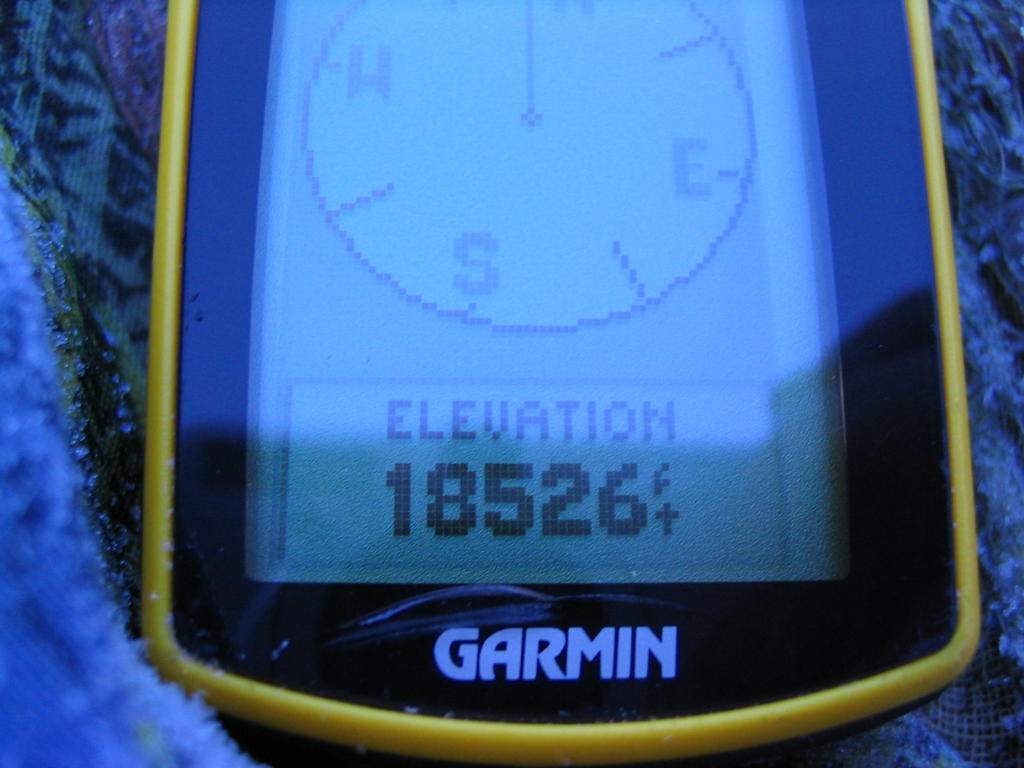
There were a bunch of other trekkers up there at the time, and a bunch of our friends that we had met along the way. We spent about two hours hanging out up there, taking lots of photos, because we had spent a lot of time acclimatising, we felt perfectly fine at that altitude, amazing. When I saw the height on the GPS, i was pretty amazed.


About 4000ft higher than I was on Rainier. The weather was pretty chilly, not sure exactly of the temp, but well below freezing. We eat some breakfast of Snickers and Mars bars at the top and watched the show of light over the mountains, fore sure a highlight of the trek.


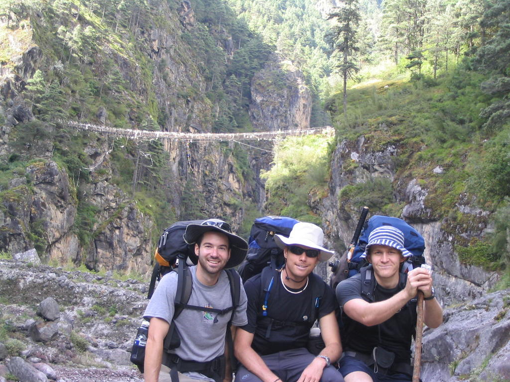
Here we are on the second day of the trek, from Phakding to Namche Bazar, still in the lush river valley, about to climb up and cross this hanging bridge. The bridges were awesome, so high up off the ground and they swing and bounce a lot when you cross them, but are super strong. we saw a bunch of Yaks crossing this before we did, but still while you're over it, it's a little scary. This one was about 100ft off the floor of the valley with a pretty rapid river benenth it...


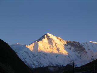
This is Cho Oyu, another 8000m peak, took this shot around 5:45am from the high village of Gokyo. Another spectacular day in the Himalaya. :)

NAMASTE!!!

The trek was glorious!!! Just got back in Kathmandu and had a massive feast at the guest house buffet... We eat really well on the trail, lots of Dal Bhat (rice, veggies, and lentils) but bacon, eggs, tomatos, potatos, were too expensive for our budget. I had three eggs, a plate of potatos, fresh tomatos, another plate of pancakes, and about a pound of bacon. and about 4 glasses of orange juice. And somehow kept it all down.

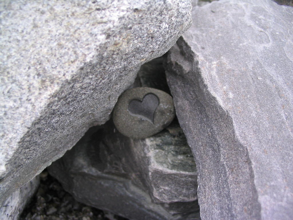
The himalaya were just too much for words to describe... We went so high, climbed to well over 18,000ft, it was unbelievable. Saw Everest for days, and tons of other huge mountains, Nuptse, Ama Dablam, Theng Kutze, they towered over us. Huge waterfalls, insane. Still stoked about it, and it's over. No shower for 15 days, mutant funk. I look like a yeti. But I took a hundred photos or so and kept the written journal well updated... So, I'll be adding to the blog shortly with a full description and photos. I'll be in Kathmandu for the next 6 days, then we drive into Tibet for 8 or 10 days, then back to Kath and onto the Annapurna circuit trek, another 16 days on that, supposed to be even better than Everest base camp. Put a heart rock with "Sweet Marya" written on the back at base camp, facing Everest, so she can watch the climbers in May.


Also put up some prayer flags at base camp, with Marya Griffin written on it. She was with me for sure, miss her.
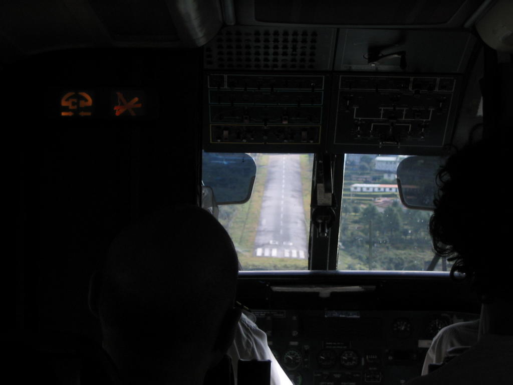
Trek details:
So on September 28th we woke up at 5am at the Kathmandu Guest House and caught a death defying taxi ride to the domestic airport. I was sitting in the front seat, as we terrifingly weaved between feral dogs, errant buses, other taxis, and people. Way too much activity for me at 5:30am. Once at the Domestic airport, which is more like a gymnasium of confusion, it's a giant room with a hundred people speaking 10 languages and all frustrated, we some how got boarding passes and through "security" which is a cheap excuse for some Nepali to play a quick game of grab ass. We took a little bus onto the runway to our Drommier 220, Short take off and Landing aircraft. This little 16 seater of noise and power was pretty wild looking. And soon we were on way over Kathmandu, towards the start of our trek and the high mountain village of Lukla.
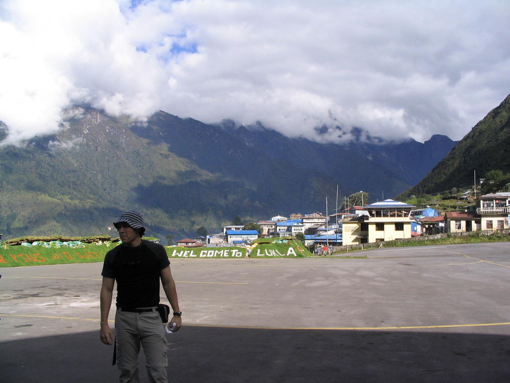
Lukla is really cool, and where most people start from now, since the maoists have checkpoints in the region below. And while that may sound dangerous, it's totally not, all they do is make you pay a 5000 rupie fee ($70), which is a pain in the butt, but not too bad considering the alternatives. So, the 'airport' at Lukla is a little strip of black top which is 180ft higher at the top than at the bottom. It's basically goes up the side of a mountain. pretty crazy.


So we landed with a thump, and quickly deplaned as helis were landing and other planes buzzing in. An intense scene for sure. So we collected our packs, which were minus matt's trekking poles, that he had bought the day before specifically for this trek, a bummer, but we picked up some hiking sticks instead.


Grabbed some breaky and headed off for our first stop, Phakding. The route went like this:

Lukla-Phakding 9/28
Phakding-Namche Bazar (stay 2 nights to acclimatize) 9/29- 30
Namche - Tengboche (stay 2 nights to acclimatize) 10/1-2
Tengboche - Pheriche (stay 2 nights to acclimatize) 10/3-4
Pheriche - Dugla 10/5
Dugla - Lobuche 10/6
Lobuche - Gorak Shep 10/7
Gorak - Dzongla 10/8
Dzongla - Gokyo (over the 17000+ft Cho La pass) 10/9
Gokyo - Namche Bazar 10/10
Namche - Lukla 10/11
Lukla Flight back to Kathmandu 10/12

Trek stats:
Distance: about 40-50 miles
Altitude: Start: 2800m/ 9200ft Top: 5646m/ 18526ft
Time: 15 days
Weather: Clear and Sunny almost every morning, mid 60's in Lukla, 20-30's at Base Camp.